Week 1- Geography and Recent Political Trends
NOTE: Before you get started, install Google Earth on your computer. Using Google Earth, try to find the various places mentioned in the text below.
Associated Readings
Associated Readings
- Harry Sanabria, “Introducing Latin America and the Caribbean,” from The Anthropology of Latin America and the Caribbean, pp. 17-49 (2007)
- Peter Smith, “A tale of two presidents,” from Democracy in Latin America, pp. 1-15 (2005)
- Matt Sandy, “Dilma Rousseff’s Impeachment Is the Start of Brazil’s Crisis—Not the End,” TIME Magazine, September 21, 2016

PART 1: GEOGRAPHY
Why does this map look funny?
Where is South America and is it the same thing as “Latin America”? The answers to these two questions, it turns out, are not so simple. In part, this is because here in the United States, we often use the terms inaccurately and inconsistently. To be fair, most U.S. citizens haven’t traveled to Latin America, so we might not expect them (that is, us) to know Latin American geography that well. Still, there is a lingering--and troubling--tendency to think of anything south of the Mexican border as South America. At best, this lumping together conceals the extraordinary cultural, linguistic, geological, and historical diversity of the territories south of the U.S. At worst, it implies a moral judgement: that "south" somehow implies less than, inferior to, beneath, etc. From that perspective, one of the reasons the map above looks "funny" is because it places us below them.
Well, let's first think about what the term "Latin America" refers to. First, a geo-political definition:
Latin America refers to all independent countries south of the United States, namely, Mexico and the nations of Central America.
According to this definition, "Latin America" looks like the following:
This is useful, but now let's consider a linguistic approach to defining this region. Instead of geopolitical borders, let's define Latin America as
the sub-region of the Americas where languages derivative of Latin are spoken.
There are only two such languages that are widely spoken in this part of the world, and they are Spanish and Portuguese. Spanish, as you probably know, is spoken in most Latin American countries, while Portuguese is only spoken in Brazil. In the map below, Spanish is in green and Portuguese is in orange:

As
you can see, there are a few countries with other colors: In Guyana
and Suriname, for example, the official language is English, while the
citizens of French Guyana speak--no surprise--French.
The linguistic approach gets more complicated if we consider not just official national languages, but all of the languages that are spoken in this world area. As it turns out, there are more than 900 "living languages" spoken in this region, as illustrated well on this map:

As you can see, if we limit "Latin America" to people who primarily
speak either Spanish or Portuguese, we are excluding huge areas and
countless communities.
And
then there's the matter of the Caribbean. As a region primarily
consisting in island nations sharing similar geography and histories of
colonization, some have argued that the Caribbean should not be
lumped together with Latin America. Others, however, have argued that
Spanish--the official language of many Caribbean nations--culturally
unites the region with Spanish-speaking countries of "mainland" Latin
America. But then again, not all of the mainland countries speak
Spanish (hello, Brazil)--and for that matter, neither do all Caribbean
nations speak Spanish (hello, Jamaica).
As
you can see, designating world areas like "Latin America" is
complicated, and may involve exclude certain people, certain language
speakers, and/or certain geographic areas. (Have a close look at
Sanabria's discussion of these terms [pp. 19-22], especially whether we
use the terms to connote "space" or "place.") This all points to the
need to be precise when we define the the area focus for our course.
Let's do that now.
For our course, we'll define South America in both geopolitical and linguistic terms terms. First, the geopolitical definition:
For our course, we'll define South America in both geopolitical and linguistic terms terms. First, the geopolitical definition:
South
America is a continent forming the southern landmass of the Americas.
(Among historians, the Americas are often referred to as "The New
World.") South America begins below Panama and extends down to the
southernmost tip of Chile.
Here's a map:

Also have a look at this map.
The
countries making up the southernmost section of South
America--Argentina, Brazil, Chile, Paraguay, and Uruguay--make up the
so-called Southern Cone. This geographic region corresponds to an important economic free trade zone, known as MercoSur. All of the preceding countries except Chile are members of MercoSur.)
But
our geopolitical definition needs to be refined in a linguistic
direction since our class will only consider countries where Spanish or
Portuguese are the national language. (Apologies to Guyana, Suriname,
and French Guyana!)
Characteristics of South America
Now
that we know what part of the world we'll focus on, let's learn more
about the geographic features of South America. Here are some important
facts about South America:
- It is situated entirely in the Western Hemisphere and mostly in the Southern Hemisphere.
- It is bordered on the west by the Pacific Ocean and on the north and east by the Atlantic Ocean.
- North America and the Caribbean Sea lie to the northwest of South America.
According to the United Nations, as of 2020, approximately 422 million people live in South America. (Compare this to the U.S. population: 328 million.) - Compared to other continents, South America ranks fourth in landmass size (after Asia, Africa, and North America) and fifth in population (after Asia, Africa, Europe, and North America).
- South America is 1.8 times as large as the United States.
Here
are some additional factoids about South America. As you look at the
links, see if you can also find each spot on Google Earth.
South America is home to...
- the world's highest waterfall, Angel Falls in Venezuela
- the largest river (by volume), the Amazon River
- the longest mountain range, the Andes
the largest rainforest, the Amazon Rainforest - the highest railroad, Ticlio, Peru
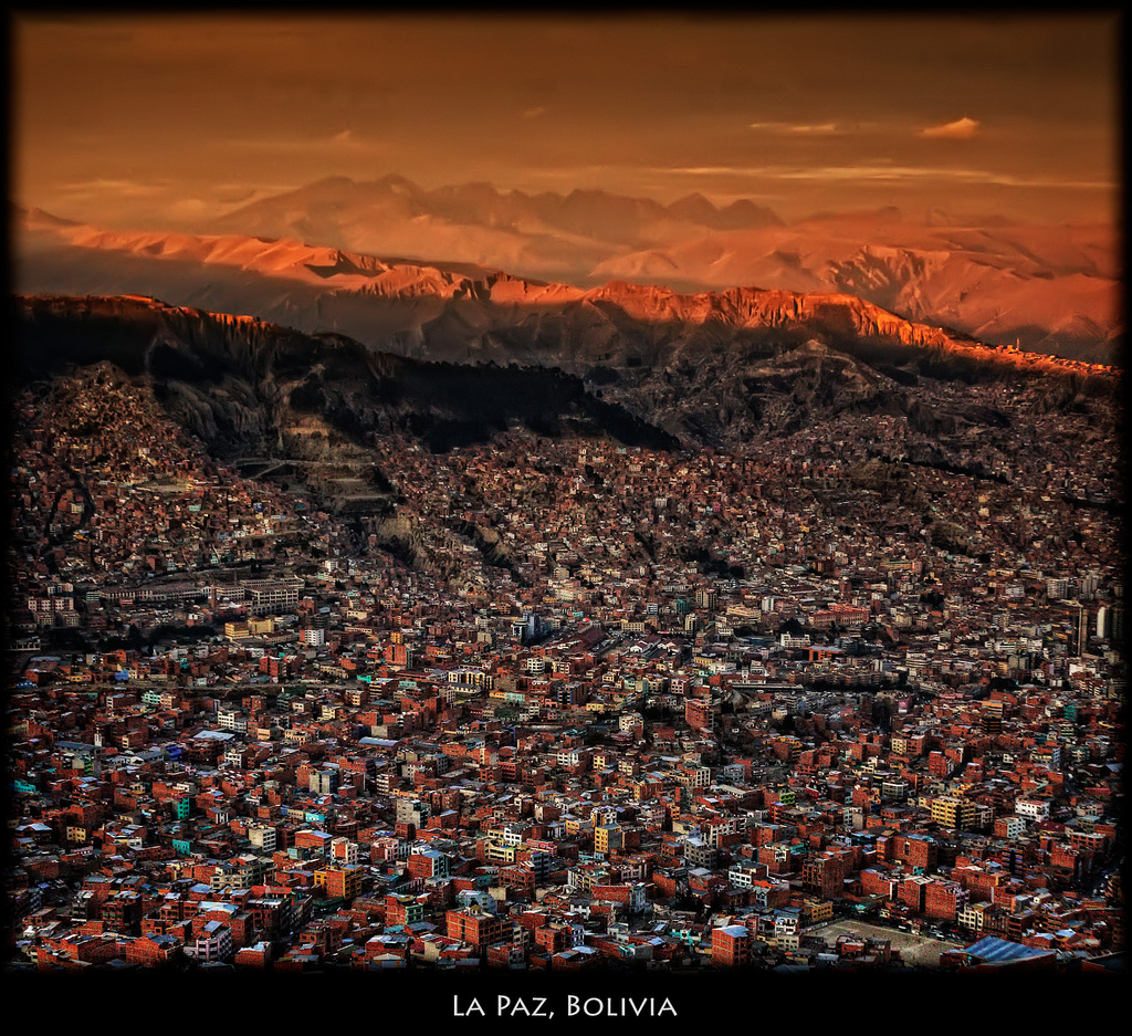
- the highest capital city, La Paz, Bolivia
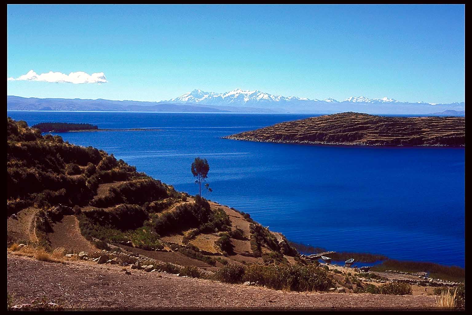
- the highest commercially navigable lake in the world, Lake Titicaca
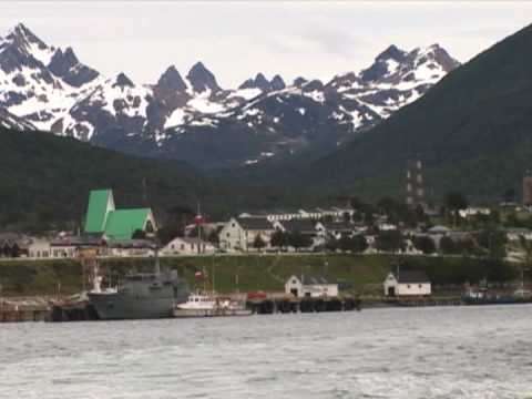
- the world's southernmost town, Puerto Toro, Chile

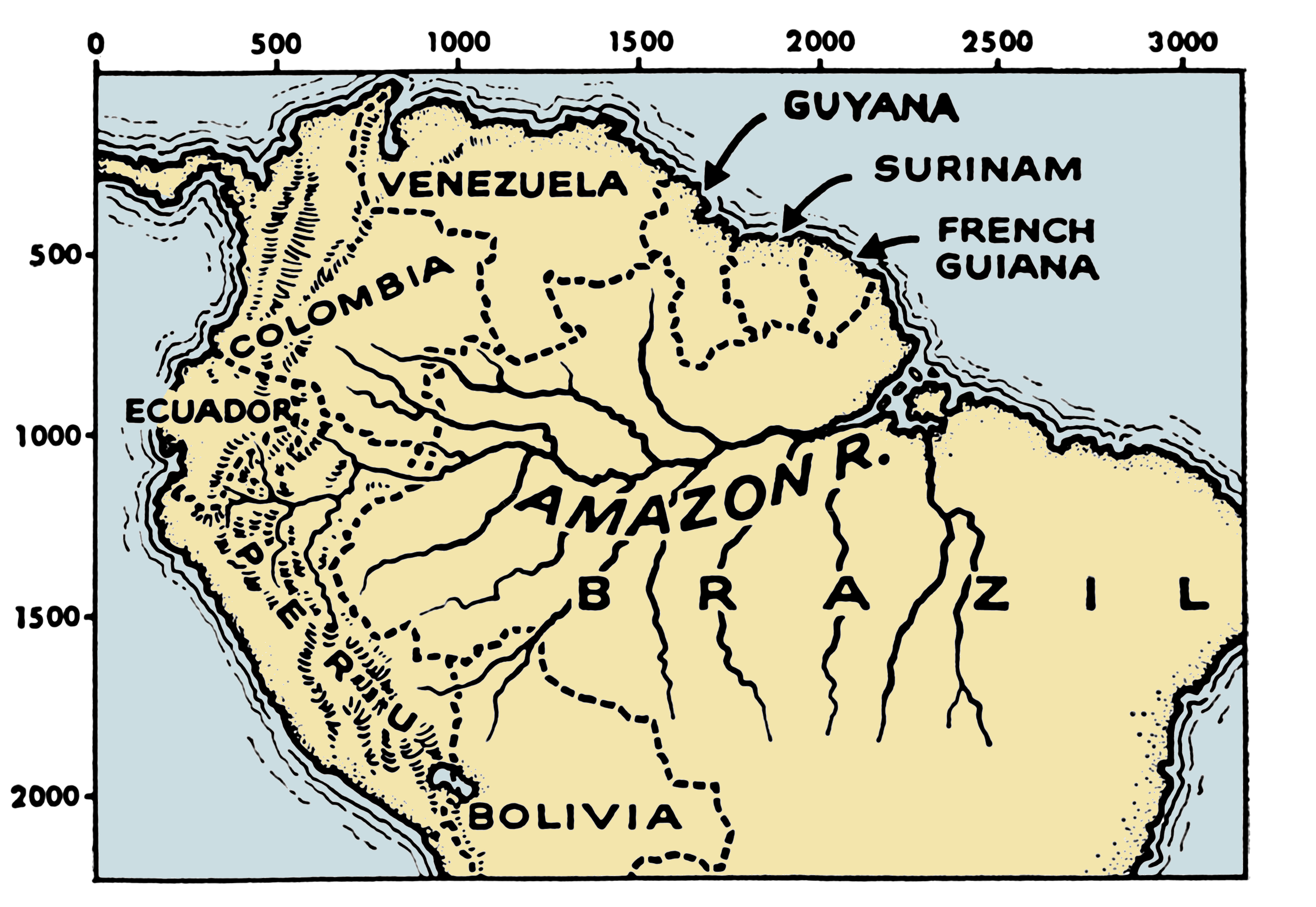
South America is characterized by two dominant physical characteristics: mountain ranges and river systems.
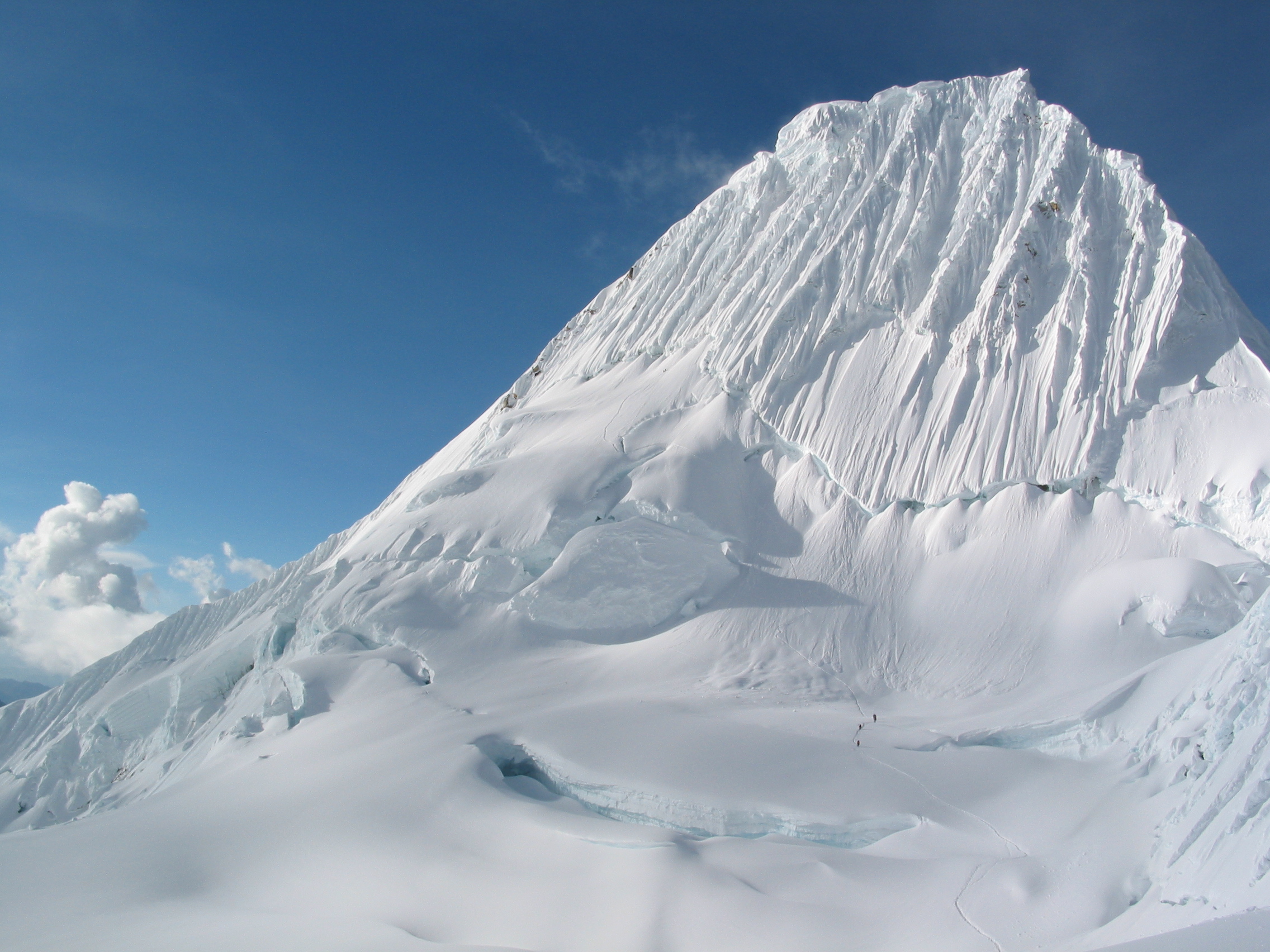
The major mountain range is the Andes. Running down the western edge of the continent, the Andes are the longest and second highest chain of mountains in the world. From their northernmost tip in Colombia to their southernmost ending in Chile, they run more than 4,300 miles and average around 13,000 feet. Many of the highest peaks are over 20,000 feet! Historically, the Andes have also posed impassible barriers to travel, trade, and communication. Even today, there are very few large highways or trains that connect the large cities on South America's west coast with those of the central highlands.
The Andes feed three river systems, each enormous in their own right:
The vast majority of South American citizens live in 4 and 5, that is, temperate coastal plains and temperate highlands.
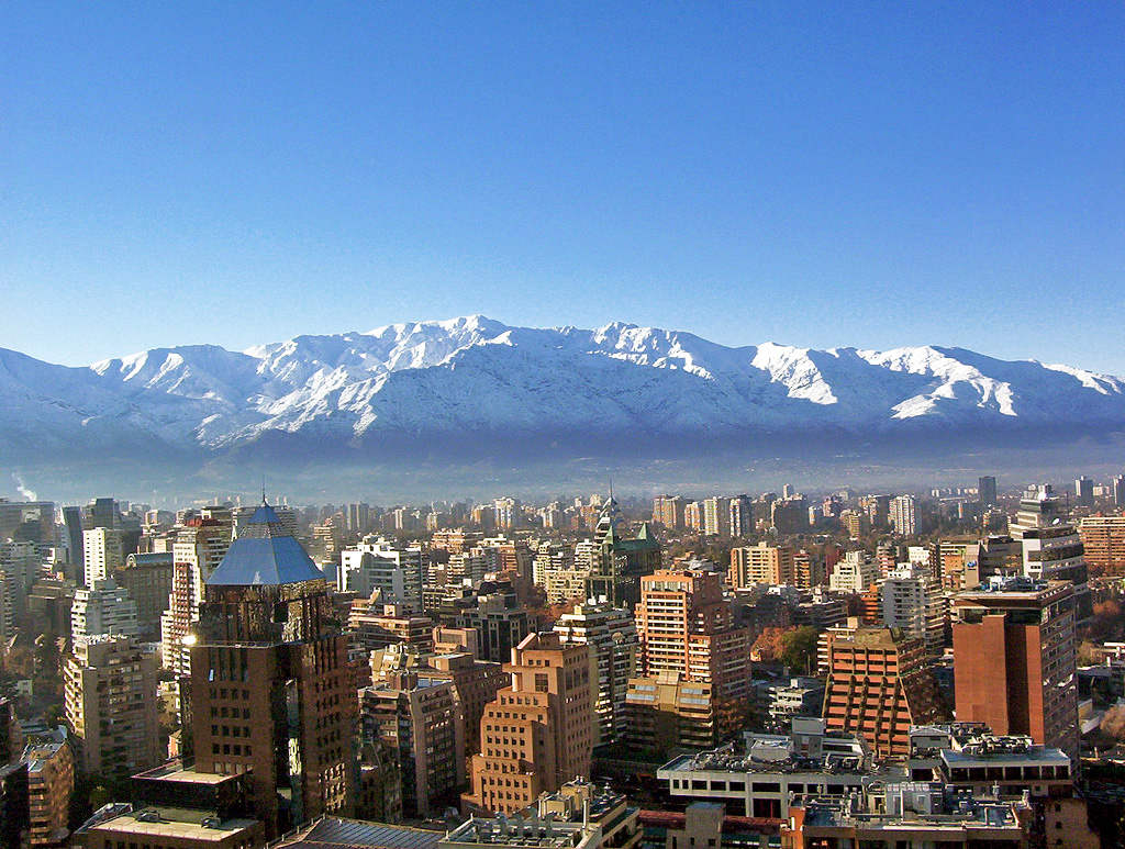
Also, a note about the coasts of South America: The continent's west coast is mostly characterized by steep mountainsides since it is the western side of the Andes mountain range. Since it's relatively difficult to build a city on a steep incline, there aren't very many large urban centers on South America's western coastline. The capitals of Chile and Peru, Santiago and Lima, are important exceptions. South America's west coast, in contrast, is much more hospitable to the construction of large cities (especially port cities such as Belém at the mouth of the Amazon river).
Sanabria provides a useful explanation of South America's ten physiographic regions (pp.32-38). Be sure to learn these, as we'll use them throughout the course.
The major mountain range is the Andes. Running down the western edge of the continent, the Andes are the longest and second highest chain of mountains in the world. From their northernmost tip in Colombia to their southernmost ending in Chile, they run more than 4,300 miles and average around 13,000 feet. Many of the highest peaks are over 20,000 feet! Historically, the Andes have also posed impassible barriers to travel, trade, and communication. Even today, there are very few large highways or trains that connect the large cities on South America's west coast with those of the central highlands.
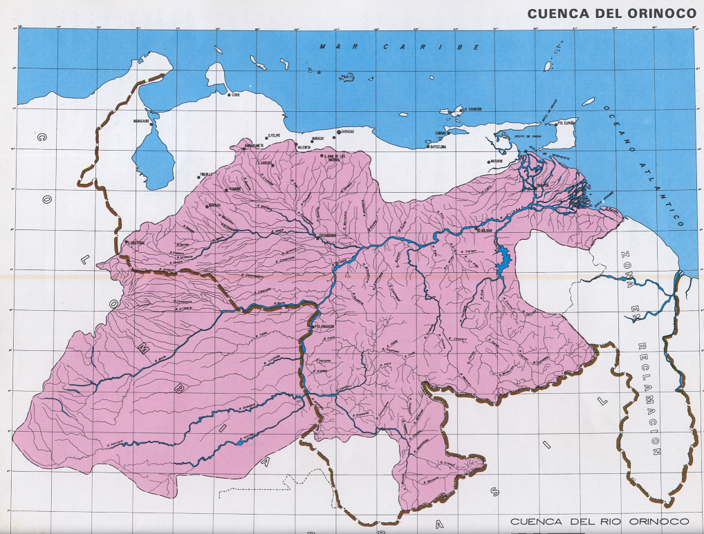
The Andes feed three river systems, each enormous in their own right:
- The Amazon, which holds a fifth of the world's fresh water and produces a fifth of the world's oxygen. (It's not for nothing that some call the Amazon "the lungs of the world"...although not everyone agrees with this label)
- The Venezuelan Orinoco river system (you might recognize this)
- The Rio de la Plata, which empties at the coastline intersection of Argentina and Uruguay.
- high mountains (principally, the Andes)
- tropical jungles (principally the Amazon)
- deserts (eastern Patagonia in Argentina, the arid Atacama desert in Peru, and the Brazilian sertão, see p. 31 of Sanabria)
- temperate coastal plains
- temperate highlands
The vast majority of South American citizens live in 4 and 5, that is, temperate coastal plains and temperate highlands.
Also, a note about the coasts of South America: The continent's west coast is mostly characterized by steep mountainsides since it is the western side of the Andes mountain range. Since it's relatively difficult to build a city on a steep incline, there aren't very many large urban centers on South America's western coastline. The capitals of Chile and Peru, Santiago and Lima, are important exceptions. South America's west coast, in contrast, is much more hospitable to the construction of large cities (especially port cities such as Belém at the mouth of the Amazon river).
Sanabria provides a useful explanation of South America's ten physiographic regions (pp.32-38). Be sure to learn these, as we'll use them throughout the course.
Peoples: Some Useful Terms
Broadly speaking, we can classify the ancestry of South America's residents into three categories: indigenous, African, and European. In contemporary South American societies, many people have mixed ancestries, and so it is useful to introduce the following two terms:
Mestizo: a mixture of indigenous and European ancestry
Mulatto: a mixture of African and European ancestry
PART 2: POLITICAL TRANSFORMATIONS
About 20 years ago, a stunning shift became apparent in the types of
presidents South American voters were electing to lead them. Increasingly, presidents from the political left were winning office. While our course is not about national politics per se, we are
nonetheless concerned with how ordinary citizens understand their
countries' pasts and possible futures--so it is worthwhile to get
familiar with recent political trends in this part of the world.
First, let's back up the claim that South American countries have been electing leftist presidents, most on the tails of lengthy periods of dictatorship. Here are the biggies from the 21st century's first decade -- all leftist and in the case of the three on top "hard left":

In Peter Smith's reading, he compares Brazil's Luiz Inácio Lula da Silva (AKA "Lula") to Venezuela's Hugo Chávez. Lula on the one hand was a former metalworker and union organizer with little formal education -- a working-class president. Chávez, on the other hand, was a career military officer who tried to overthrow the government in the 1990s before being elected in 2004.
Let's get more familiar with Lula, elected in 2002 and in office for two terms until 2010, and with Bolivia's president from 2006-19, Aymará Indian and former coca farmer Evo Morales, elected in 2005.
First Lula. Watch this short dispatch from 2004 by a New York Times journalist, on the rise of Lula and some of the reasons for his mass appeal to Brazil's poor.
Next Morales. This 2005 dispatch comes from New York Times and Washington Post journalist, Juan Forero. Forero was in Bolivia, covering the home stretch of the presidential election campaigns which would eventually lead to Morales' election. Please read Forero's short article now, and then watch his short dispatch.
As
you can see, Lula, Morales, and Chávez have a lot of differences in
terms of their personal backgrounds, ethnic, and class identities. As
we move forward in the course, we'll learn a lot more about these
differences.) But they also share several core commitments (at least what they say
are their commitments). So here is a short and much simplified list of
official ideological commitments of early 21st-century leftist presidents in
South America:
- Reducing poverty
- Social welfare (health, education, hunger)
- The rights of minority populations, principally, indigenous people, women, rural peasants, people of African descent, and lesbian/gay/bisexual/transgender (LGBT) people
- Economic development but while protecting national economies from the world market
- The establishment of a Regional Trade Zone -- like MercoSur, but for all of South America or even all of Latin America.
BIG CHANGES: Introducing the "Post-Pink" Moment
As you will see as we move forward, Latin America's "turn to the left" (the so-called "pink tide") now seems a thing of the past. Across the region, we see a broad pattern: the dissolution or dismantling of progressive, welfare-oriented political regimes and replacement by what seem to be conservative or market-oriented regimes. Please watch this five-minute interview with MIT linguist and globalization theorist Noam Chomsky. (Want more? You can see Prof. Chomsky's 2011 visit to SUNY New Paltz here.) Don't worry too much about the details at this point, though pay attention to the similarities you see between countries. In the weeks to come, we'll consider different explanations for these region-wide turns away from leftist political regimes, and learn about how these transformations have been experienced by ordinary people across Latin America.


Comments
Post a Comment